![Picture of Mahibur Fakir [Hillol]](https://secure.gravatar.com/avatar/5d35a11815be0a5f73b6180975d1521fdd7694c880473d8ad5c74749dce26bd6?s=96&d=mm&r=g)
China’s Medog Dam: The Project of the Century That Could Reshape Bangladesh’s Future
By Living Arcade News Desk | May 2, 2026
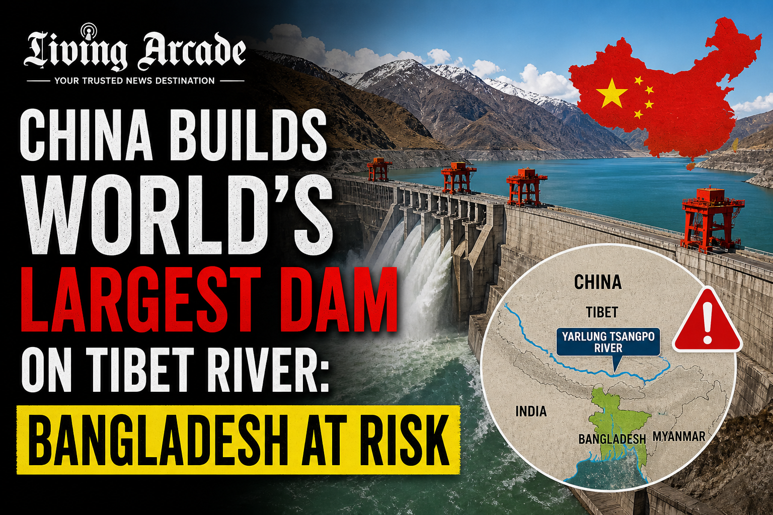
High in the mountains of Tibet, where the air is thin and the gorges plunge deeper than anywhere else on earth, China has begun building something that has never existed before. The Medog Hydropower Station is a planned 60,000-megawatt run-of-the-river hydroelectric dam project under development on the Yarlung Tsangpo River in the Tibet Autonomous Region of China. Upon completion, it will become the world’s largest hydropower facility, with an anticipated annual power generation capacity of 300 billion kilowatt-hours, which is triple that of the Three Gorges Dam.
For China, this is an engineering triumph and a climate milestone. For Bangladesh, which sits at the very end of this river’s long journey to the sea, it may be one of the most consequential decisions ever made by a foreign government about the future of this nation’s water, food, and survival.
A Dam Unlike Anything Ever Built
The Chinese government authorized the dam’s construction in December 2024, with an estimated investment exceeding 1 trillion yuan, approximately 137 billion dollars. Construction officially began on July 19, 2025. The project is intended to be developed as a single-phase installation, with commercial operations planned for 2033. The facility is planned to be constructed in Medog County within the Nyingtri Prefecture, situated near the Indian border state of Arunachal Pradesh.
Chinese Premier Li Qiang attended the commencement ceremony for the dam, describing it as a project of the century, and said special emphasis must be placed on ecological conservation to prevent environmental damage.
What makes this project so extraordinary from an engineering standpoint is the geography it exploits. The dam will harness the immense latent hydropower from the Great Bend, a steep canyon where the Yarlung Zangbo makes a horseshoe turn and then drops more than 2,000 metres over a 50-kilometre stretch. The published technical details indicate an audacious plan to bore a tunnel through the Himalayas to divert some of the river, flowing through five cascading underwater hydropower stations within the tunnel.
One of the key features of the site is a dramatic 2,000-meter drop within a stretch of just 50 kilometers along the Yarlung Zangbo River, offering immense hydropower potential. No dam site anywhere on the planet offers this combination of height, volume, and velocity.
The River That Becomes Bangladesh’s Jamuna
This is where the story becomes deeply personal for every Bangladeshi. The Yarlung Zangbo becomes the Brahmaputra river as it leaves Tibet and flows south into India’s Arunachal Pradesh and Assam states and finally into Bangladesh. The river comes to be known as the Jamuna when another tributary, the Teesta, flows into the Brahmaputra. Further downstream, the Jamuna flows into the Ganga and is known as the Padma thereafter. The main body of the Padma reaches its confluence with the Meghna River near Chandpur in Bangladesh before entering the Bay of Bengal.
This is not a distant foreign river. This is the same water that fills Bangladesh’s fields, feeds its fish, and quenches the thirst of tens of millions of people from Sylhet to Sirajganj to Dhaka.
What Bangladesh Stands to Lose
As the Brahmaputra transforms into the Jamuna River in Bangladesh, its flow is crucial for more than 160 million people. Bangladesh, already facing acute water stress and climate change challenges, depends on the river for agriculture, covering 55 percent of its irrigation needs, as well as drinking water and fisheries.
Bangladesh receives about 70 percent of its lean season flow through the Brahmaputra-Jamuna river. Any uncertainty and disruption in the flow will have a devastating impact on agriculture, irrigation, fisheries, and navigation.
The specific threats experts have identified are alarming in their range and depth. Large dams typically trap sediments, which can lead to riverbed degradation, loss of soil fertility, collapse of local fisheries, decline in migratory species like hilsa and mahseer that are critical for regional livelihood, intrusion of saline water in coastal regions of Bangladesh, and decline in sedimentation rates on coastal plains necessary to offset rising sea levels caused by climate change.
China’s dam in Medog County could alter water flow in the Brahmaputra, potentially reducing availability during the dry season and exacerbating flood risks during monsoons. Experts warn that such changes could affect agriculture, fisheries, and sediment flow in downstream regions of India and Bangladesh, with significant implications for food security and livelihoods.
For a country like Bangladesh, where millions of farmers depend entirely on river-fed irrigation to grow rice, and where hilsa fishing is both a cultural identity and an economic lifeline, these are not abstract statistics. They are descriptions of potential catastrophe.
The Seismic Nightmare
Beyond the water management risks lies another threat that geologists describe in genuinely alarming terms. The location in a tectonically active zone means that landslides into the reservoir are likely, and the weight of the impounded water could trigger reservoir-induced seismic events. The Great Bend canyon lies near the epicentre of the 8.6-magnitude Assam-Tibet earthquake in 1950, one of the strongest ever recorded on land.
Large-scale infrastructure projects in seismically active regions such as the Himalayas increase the likelihood of landslides and earthquakes. The Yarlung Tsangpo Basin is highly sensitive. A catastrophic structural failure at this dam, triggered by an earthquake of the scale the region has historically produced, would send a wall of water toward India’s Assam and ultimately toward Bangladesh with consequences that no disaster planning framework has ever had to contemplate.
China’s Goals: Clean Energy and Geopolitical Leverage
To understand why China is building this dam, it is important to understand what it gains. The dam is part of the vision of Tibet as a clean energy supply base for the West-to-East Power Transmission programme. The electricity is not intended for local use, but for export to eastern provinces via ultra-high-voltage transmission lines.
Along with the announcement of the hydropower project, the Chinese government also launched China Yajiang Group Co., Ltd., a state-owned enterprise specifically established to oversee the construction and operation of this strategically significant project.
But the implications go far beyond electricity. The project has surfaced anxieties about the geopolitics of water, as Chinese control over the river could strain relations with New Delhi and Dhaka by strengthening Beijing’s leverage over downstream water flows into South Asia.
A 2020 report published by the Lowy Institute noted that control over these rivers effectively gives China a chokehold on India’s economy. The Chief Minister of India’s Arunachal Pradesh expressed concern that China could even use this as a sort of water bomb.
Bangladesh has not publicly confronted China on this issue with the same force as India, perhaps because of its complex diplomatic relationships with both nations. But the silence from Dhaka does not make the risk disappear.
What Has Bangladesh Said?
Bangladesh has expressed concerns over water security due to China’s construction of the Medog Hydropower Station, which flows downstream into Bangladesh as the Jamuna River.
Bangladesh, being the most downstream country in the Yarlung Zangbo-Sian-Brahmaputra-Jamuna river watershed, should be worried about any unilateral control of transboundary rivers by any upstream nation including India and China. Bangladesh should strongly oppose this project. That is the view of water experts in Dhaka. Whether the government acts on it through international diplomatic channels remains to be seen.
No Environmental Impact Assessment Made Public
Perhaps the most troubling single fact about this entire project is this: The Chinese government has not yet released comprehensive environmental impact assessments or detailed implementation plans for the project.
A dam that will reshape the hydrology of an entire subcontinent, affect the livelihoods of hundreds of millions of people across three nations, and sit atop one of the most seismically active regions on earth is being built without the downstream countries having access to a single published environmental study. That is not engineering. That is geopolitical unilateralism.
The Precedent and the Warning
China’s earlier hydropower projects, such as the Three Gorges Dam, have demonstrated the unintended consequences of large-scale sediment disruption, including reduced agricultural productivity and diminished biodiversity downstream. The Yarlung Zangbo River, the lifeblood of many ecosystems in South Asia, could face similar degradation, affecting not just local environments but also neighboring countries dependent on its waters.
In the 1960s, the transboundary rivers used to carry over 2 billion tons of sediments to Bangladesh annually, which has declined to about 1 billion tons in recent decades. Dams reduce downstream sediment supply, increasing the erosive power of water and interrupting the natural land-building process needed to offset sea-level rise. The Medog Dam would accelerate exactly this process at a moment when Bangladesh’s coastal lands are already sinking.
The Yarlung Zangbo begins its life as snowmelt and glacial water on the Tibetan Plateau, 5,000 metres above sea level, thousands of kilometres from the Bay of Bengal. By the time it reaches Bangladesh it is the Jamuna, brown and vast and indispensable. China has decided, without consultation, what happens to that river first. Bangladesh must now decide what it will do about that.
![Picture of Mahibur Fakir [Hillol]](https://secure.gravatar.com/avatar/5d35a11815be0a5f73b6180975d1521fdd7694c880473d8ad5c74749dce26bd6?s=176&d=mm&r=g)